See our Bangladesh
THE SUNDERBAN
The history of the area can be traced back to 200–300 AD. A ruin of a city built by Chand Sadagar has been found in the Baghmara Forest Block. During the Mughal period, the Mughal Kings leased the forests of the Sundarbans to nearby residents. Many criminals took refuge in the Sundarbans from the advancing armies of Emperor Akbar. Many have been known to be attacked by Tigers[2] Many of the buildings which were built by them later fell to hands of Portuguese pirates, salt smugglers and dacoits in the 17th century. Evidence of the fact can be traced from the ruins at Netidhopani and other places scattered all over management mostly were staffed by locals[4]
The first Forest Management Division to have jurisdiction over the Sundarbans was established in 1869. In 1875 a large portion of the mangrove forests was declared as reserved forests in 1875–76 under the Forest Act, 1865 (Act VIII of 1865). The remaining portions of the forests were declared a reserve forest the following year and the forest, which was so far administered by the civil administration district, was placed under the control of the Forest Department. A Forest Division, which is the basic forest management and administration unit, was created in 1879 with the headquarter in Khulna, Bangladesh. The first management plan was written for the period 1893–98.[5][6]
In 1911, it was described as a tract of waste country which had never been surveyed, nor had the census been extended to it. It then stretched for about 165 miles (266 km) from the mouth of the Hugli to the mouth of the Meghna river and was bordered inland by the three settled districts of the 24 Parganas, Khulna and Bakerganj. The total area (including water) was estimated at 6,526 square miles (16,902 km2). It was a water-logged jungle, in which tigers and other wild beasts abounded. Attempts at reclamation had not been very successful. The Sundarbans was everywhere intersected by river channels and creeks, some of which afforded water communication throughout the Bengal region both for steamers and for native boats.
Geography

The Sundarbans is intersected by a complex network of tidal waterways, mudflats and small islands of salt-tolerant mangrove forests. The interconnected network of waterways makes almost every corner of the forest accessible by boat. The area is known for the eponymous Royal Bengal Tiger (Panthera tigris tigris), as well as numerous fauna including species of birds, spotted deer, crocodiles and snakes. The fertile soils of the delta have been subject to intensive human use for centuries, and the ecoregion has been mostly converted to intensive agriculture, with few enclaves of forest remaining. The remaining forests, taken together with the Sundarbans mangroves, are important habitat for the endangered tiger. Additionally, the Sundarbans serves a crucial function as a protective barrier for the millions of inhabitants in and around Khulna and Mongla against the floods that result from the cyclones. The Sundarbans has also been enlisted among the finalists in the New7Wonders of Nature.
Sundarbans.[3] The legal status of the forests underwent a series of changes, including the distinction of being the first mangrove forest in the world to be brought under scientific management. The area was mapped first in Persian, by the Surveyor General as early as 1764 following soon after proprietary rights were confiscated from the Mughal Emperor Alamgir II by the British East India Company in 1757. As the British had no expertise or adaptation experience in mangrove forests. Systematic management of this forest tract started in the 1860s after the establishment of a Forest Department in the Province of Bengal, in British India. The management was entirely designed to extract whatever treasures were available, but labor and lower
wild life of sunderban

Cox's Bazar (Bengali: কক্সবাজার) is a town, a fishing port and district headquarters in Bangladesh. It is known for its wide sandy beach which is the world's longest natural sandy sea beach. It is an unbroken 125 km sandy sea beach with a gentle slope. It is located 150 km south of the industrial port Chittagong. Cox’s Bazar is also known by the name "Panowa", the literal translation of which means "yellow flower". Its other old name was "Palongkee". The modern Cox's Bazar derives its name from Captain Hiram Cox (died 1799), an officer serving in British India. An officer of the British East India Company, Captain Cox was appointed Superintendent of Palongkee outpost after Warren Hastings became Governor of Bengal. Captain Cox was specially mobilised to deal with a century-long conflict between Arakan refugees and local Rakhains. The Captain was a compassionate soul and the plight of the people touched his heart. He embarked upon the mammoth task of rehabilitating refugees in the area and made significant progress. A premature death took Captain Cox in 1799 before he could finish his work. But the work he had done earned him a place in the hearts of the locals, and to commemorate his role in rehabilitation work a market was established and named after him Cox's Bazaar ("Cox's Market").
Today, Cox's Bazar is one of the most-visited tourist destinations in Bangladesh, however it has yet to become a major international tourist destination, with no international hotel chains operating here, due to lack of publicity and transportation.


After the end of British rule in 1947, Cox's Bazar remained as a part of East Pakistan. Captain Advocate Fazlul Karim, the first Chairman (after independence from the British) of Cox's Bazar Municipality established the Tamarisk Forest along the beach to draw tourist attention in this town and also to protect the beach from tidal waves. He also donated many of his father in law’s and his own lands for establishing a Public Library and a Town Hall for the town. He was inspired to build Cox's Bazar as a tourist spot after seeing beaches of Bombay and Karachi, and one of the pioneers in developing Cox's Bazar as such. He founded a Maternity Hospital, the Stadium and the drainage system by procuring grants from the Ford Foundation and Rockefeller Foundation through correspondence. Mr. T. H. Matthews, the principal of the Dacca Engineering College (1949~1954) was his friend who had helped him in doing this. Engineer Chandi Charan Das was the government civil engineer who had worked on all these projects. In 1959 the municipality was turned into a town committee.In 1961 the erstwhile Geological Survey of Pakistan initiated investigation of radioactive minerals like monazite around the cox's bazar sea-beach area and a number of precious heavy minerals were identified the same year.
In 1971, Cox's bazar wharf was used as a naval port by the Pakistan Navy's gunboats. This and the nearby airstrip of the Pakistan Air Force were the scene of intense shelling by the Indian Navy during Bangladesh Liberation War. During the war, Pakistani soldiers killed many people in the town including eminent lawyer Jnanendralal Chowdhury. The killing of two freedom fighters named Farhad and Subhash at Badar Mokam area is also recorded in history.
After the independence of Bangladesh Cox's Bazar started to get the administrative attention. In 1972 the town committee of Cox's Bazar was again turned into a municipality. In 1975, The Government of Bangladesh established a pilot plant at Kalatali, Cox's Bazar to assess the commercial viability of the heavy mineral content in the placer deposits of the area with the cooperation of the Australian Government.Later, in 1984 Cox's Bazar subdivision was promoted to a district and 5 years later (in 1989) the Cox's Bazar municipality was elevated to B-grade. In 1994 (jobs) the Marine Fisheries and Technology Station (MFTS) was established at Cox's Bazar. MFTS is a research station of Bangladesh Fisheries Research Institute (BFRI) headquartered in Mymensingh. The station covers a land area of 4 hactor and is equipped with 5 specialised laboratories, and one indoor and one outdoor cistern complex. In April 2007 Bangladesh got connected to the submarine cable network as a member of the SEA-ME-WE-4 Consortium, as Cox's Bazar was selected as the landing station of the submarine cable.
Cox's Bazar town with an area of 6.85 km², is located at 21°35′0″N 92°01′0″E and bounded by Bakkhali River on the north and East, Bay of Bengal in the West, and Jhilwanj Union in the south.
The climate of Bangladesh is mostly determined by its location in the tropical monsoon region: high temperature, heavy rainfall, often excessive humidity, and distinct seasonal variations. The reversal of the wind circulation between summer and winter is another important feature of the climate of the country.The climate of Cox's bazar is mostly similar to the rest of the country. It is further characterised by the location in the coastal area. The annual average temperature in Cox's Bazar remains at about a maximum of 34.8 °C and a minimum of 16.1 °C. The average amount of rainfall remains at 4,285 mm.

Submarine Cable Landing Station


THE SUNDERBAN
The first Forest Management Division to have jurisdiction over the Sundarbans was established in 1869. In 1875 a large portion of the mangrove forests was declared as reserved forests in 1875–76 under the Forest Act, 1865 (Act VIII of 1865). The remaining portions of the forests were declared a reserve forest the following year and the forest, which was so far administered by the civil administration district, was placed under the control of the Forest Department. A Forest Division, which is the basic forest management and administration unit, was created in 1879 with the headquarter in Khulna, Bangladesh. The first management plan was written for the period 1893–98.[5][6]
In 1911, it was described as a tract of waste country which had never been surveyed, nor had the census been extended to it. It then stretched for about 165 miles (266 km) from the mouth of the Hugli to the mouth of the Meghna river and was bordered inland by the three settled districts of the 24 Parganas, Khulna and Bakerganj. The total area (including water) was estimated at 6,526 square miles (16,902 km2). It was a water-logged jungle, in which tigers and other wild beasts abounded. Attempts at reclamation had not been very successful. The Sundarbans was everywhere intersected by river channels and creeks, some of which afforded water communication throughout the Bengal region both for steamers and for native boats.
 |
| Royal Bengal Tiger |
Geography
 |
A Panaroma atop an observation post at Hiron Point Wild Life Sanctuary, Khulna Range, Bangladesh
|
 |
| Heritage world of Sunderban |
The Sundarban forest lies in the vast delta on the Bay of Bengal formed by the super confluence of the Padma, Brahmaputra and Meghna rivers across southern Bangladesh. The seasonally flooded Sundarbans freshwater swamp forests lie inland from the mangrove forests on the coastal fringe. The forest covers 10,000 km2. of which about 6,000 are in Bangladesh.[7] It became inscribed as a UNESCO world heritage site in 1997. The Sundarbans is estimated to be about 4,110 km², of which about 1,700 km² is occupied by waterbodies in the forms of river, canals and creeks of width varying from a few meters to several kilometers.
 |
| river of sunderban |
 |
| MAP OF SUNDERBAN |
Sundarbans.[3] The legal status of the forests underwent a series of changes, including the distinction of being the first mangrove forest in the world to be brought under scientific management. The area was mapped first in Persian, by the Surveyor General as early as 1764 following soon after proprietary rights were confiscated from the Mughal Emperor Alamgir II by the British East India Company in 1757. As the British had no expertise or adaptation experience in mangrove forests. Systematic management of this forest tract started in the 1860s after the establishment of a Forest Department in the Province of Bengal, in British India. The management was entirely designed to extract whatever treasures were available, but labor and lower
 |
| deer in the sunderban |
wild life of sunderban
Cox's Bazar

Cox's Bazar (Bengali: কক্সবাজার) is a town, a fishing port and district headquarters in Bangladesh. It is known for its wide sandy beach which is the world's longest natural sandy sea beach. It is an unbroken 125 km sandy sea beach with a gentle slope. It is located 150 km south of the industrial port Chittagong. Cox’s Bazar is also known by the name "Panowa", the literal translation of which means "yellow flower". Its other old name was "Palongkee". The modern Cox's Bazar derives its name from Captain Hiram Cox (died 1799), an officer serving in British India. An officer of the British East India Company, Captain Cox was appointed Superintendent of Palongkee outpost after Warren Hastings became Governor of Bengal. Captain Cox was specially mobilised to deal with a century-long conflict between Arakan refugees and local Rakhains. The Captain was a compassionate soul and the plight of the people touched his heart. He embarked upon the mammoth task of rehabilitating refugees in the area and made significant progress. A premature death took Captain Cox in 1799 before he could finish his work. But the work he had done earned him a place in the hearts of the locals, and to commemorate his role in rehabilitation work a market was established and named after him Cox's Bazaar ("Cox's Market").
Today, Cox's Bazar is one of the most-visited tourist destinations in Bangladesh, however it has yet to become a major international tourist destination, with no international hotel chains operating here, due to lack of publicity and transportation.
| Country | |
|---|---|
| Administrative District | Cox's Bazar District |
| Area | |
| • City | 6.85 km2 (2.64 sq mi) |
| Population (2007 est.)Total population represents population in city and metro represents entire district.[1] | |
| • City | 51,918 |
| • Density | 7,579.27/km2 (19,630.2/sq mi) |
| • Metro | 120,480 |
| Time zone | BST (UTC+6) |
The Town
 | |
| Cox's bazar Bus terminal |

Cox's Bazar (Town) Cox's Bazar municipality was constituted in 1869 and was turn into a town committee in 1959. The town committee was again replaced by municipality in 1972 and it was elevated to B-grade in 1989. The municipality covers an area of 6.85 sq km with 27 mahallas and 9 wards; population 60234; male 57.09%, female 42.91%. The literacy rate among the town people is 52.2%. Cox's Bazar having been a great tourist resort various establishments have developed in the town including 6 big hotels, 30 medium hotels, 50 semi-medium hotels, Jhinuk market for the tourists and the Burmese market dealing in luxury goods from Burma, Thailand and China.Located along the Bay of Bengal in South Eastern Bangladesh, Cox's Bazar Town is a very big port and health resort. But it is mostly famous for its long natural sandy beach. The municipality covers an area of 6.85 km² with 27 mahallas and 9 wards and has a population of 51,918.Cox's Bazar is connected by road and air with Chittagong.
History
The greater Chittagong area including Cox's Bazar was under the rule of Arakan Kings from the early 9th century till its conquest by the Mughals in 1666 AD. When the Mughal Prince Shah Shuja was passing through the hilly terrain of the present day Cox’s Bazar on his way to Arakan, he was attracted to the scenic and captivating beauty of the place. He commanded his forces to camp there. His retinue of one thousand palanquins stopped there for some time. A place named Dulahazara, meaning "one thousand palanquins", still exists in the area. After the Mughals, the place came under the control of the Tipras and the Arakanese, followed by the Portuguese and then the British.
The name Cox's Bazar/Bazaar originated from the name of a British East India Company officer, Captain Hiram Cox who was appointed as the Superintendent of Palonki (today's Cox's Bazar) outpost after Warren Hastings became the Governor of Bengal following the British East India Company Act in 1773. Captain Cox was especially mobilised to deal with a century long conflict between Arakan refugees & local Rakhains at Palonki. The Captain made significant progress in rehabilitation of refugees in the area, but had died (in 1799) before he could finish his work. To commemorate his role in rehabilitation work a market / bazaar was established and was named after him as Cox's Bazaar (market of Cox). Cox's Bazar thana was first established in 1854 and a municipality was constituted in 1869.
After the Sepoy Mutiny (Indian Rebellion of 1857) in 1857, the British East India Company was highly criticised & questioned on humanitarian grounds, specially for its Opium trade monopoly over the Indian Sub-Continent. However, after its dissolution on 1 January 1874, all of the company's assets including its Armed Forces were acquired by the British Crown. After this historic take over, Cox's Bazar was declared a district of the Bengal Province under the British Crown.
After the end of British rule in 1947, Cox's Bazar remained as a part of East Pakistan. Captain Advocate Fazlul Karim, the first Chairman (after independence from the British) of Cox's Bazar Municipality established the Tamarisk Forest along the beach to draw tourist attention in this town and also to protect the beach from tidal waves. He also donated many of his father in law’s and his own lands for establishing a Public Library and a Town Hall for the town. He was inspired to build Cox's Bazar as a tourist spot after seeing beaches of Bombay and Karachi, and one of the pioneers in developing Cox's Bazar as such. He founded a Maternity Hospital, the Stadium and the drainage system by procuring grants from the Ford Foundation and Rockefeller Foundation through correspondence. Mr. T. H. Matthews, the principal of the Dacca Engineering College (1949~1954) was his friend who had helped him in doing this. Engineer Chandi Charan Das was the government civil engineer who had worked on all these projects. In 1959 the municipality was turned into a town committee.In 1961 the erstwhile Geological Survey of Pakistan initiated investigation of radioactive minerals like monazite around the cox's bazar sea-beach area and a number of precious heavy minerals were identified the same year.
In 1971, Cox's bazar wharf was used as a naval port by the Pakistan Navy's gunboats. This and the nearby airstrip of the Pakistan Air Force were the scene of intense shelling by the Indian Navy during Bangladesh Liberation War. During the war, Pakistani soldiers killed many people in the town including eminent lawyer Jnanendralal Chowdhury. The killing of two freedom fighters named Farhad and Subhash at Badar Mokam area is also recorded in history.
After the independence of Bangladesh Cox's Bazar started to get the administrative attention. In 1972 the town committee of Cox's Bazar was again turned into a municipality. In 1975, The Government of Bangladesh established a pilot plant at Kalatali, Cox's Bazar to assess the commercial viability of the heavy mineral content in the placer deposits of the area with the cooperation of the Australian Government.Later, in 1984 Cox's Bazar subdivision was promoted to a district and 5 years later (in 1989) the Cox's Bazar municipality was elevated to B-grade. In 1994 (jobs) the Marine Fisheries and Technology Station (MFTS) was established at Cox's Bazar. MFTS is a research station of Bangladesh Fisheries Research Institute (BFRI) headquartered in Mymensingh. The station covers a land area of 4 hactor and is equipped with 5 specialised laboratories, and one indoor and one outdoor cistern complex. In April 2007 Bangladesh got connected to the submarine cable network as a member of the SEA-ME-WE-4 Consortium, as Cox's Bazar was selected as the landing station of the submarine cable.
Geography and climate
The climate of Bangladesh is mostly determined by its location in the tropical monsoon region: high temperature, heavy rainfall, often excessive humidity, and distinct seasonal variations. The reversal of the wind circulation between summer and winter is another important feature of the climate of the country.The climate of Cox's bazar is mostly similar to the rest of the country. It is further characterised by the location in the coastal area. The annual average temperature in Cox's Bazar remains at about a maximum of 34.8 °C and a minimum of 16.1 °C. The average amount of rainfall remains at 4,285 mm.
| Climate data for Cox's Bazar | |||||||||||||||||||||||||||||||||||||||||
|---|---|---|---|---|---|---|---|---|---|---|---|---|---|---|---|---|---|---|---|---|---|---|---|---|---|---|---|---|---|---|---|---|---|---|---|---|---|---|---|---|---|
| Month | Jan | Feb | Mar | Apr | May | Jun | Jul | Aug | Sep | Oct | Nov | Dec | Year | ||||||||||||||||||||||||||||
| Average high °C (°F) | 27 (80) | 28 (83) | 31 (87) | 32 (90) | 33 (91) | 31 (87) | 30 (86) | 30 (86) | 31 (87) | 31 (87) | 29 (85) | 27 (80) | 29.9 (86) | ||||||||||||||||||||||||||||
| Average low °C (°F) | 14 (57) | 16 (61) | 20 (68) | 24 (75) | 26 (78) | 25 (77) | 27 (81) | 25 (77) | 25 (77) | 24 (75) | 19 (67) | 16 (60) | 21.7 (71.1) | ||||||||||||||||||||||||||||
| Precipitation mm (inches) | 3 (0.1) | 13 (0.5) | 38 (1.5) | 107 (4.2) | 323 (12.7) | 790 (31.1) | 902 (35.5) | 706 (27.8) | 389 (15.3) | 183 (7.2) | 84 (3.3) | 25 (1.0) | 3,559 (140.1) | ||||||||||||||||||||||||||||
| Source: Weatherbase | |||||||||||||||||||||||||||||||||||||||||
Economy and development

As one of the most beautiful and famous tourist spots in Bangladesh, the major source of economy in Cox's Bazar is tourism. Millions of foreigners and Bangladeshi natives visit this coastal city every year. As a result, a large number of hotels, guest houses and motels have been built in the city and coastal region. Many people are involved in hospitality and customer service orientated businesses. Number of high-end hotels in the city was about 2 or 3 about 5 years ago, but today there are dozens and counting, however no renowned international hotel chains operate in the city, but many hotel chains are planning to build hotels here, such as the Carlson Rezidor Hotel Group plans 2 Radissons here in 2015, and another in the port city Chittagong. Also, a Best Western hotel which opens in 2014, also Mövenpick Hotels & Resorts will open a Mövenpick Hotel in 2013.[17][18]
A number of people are also involved in fishing and collecting seafood and sea products for their livelihood. Various kinds of Oyster, Snail, Pearl and their ornaments are very popular with tourists in seaside and city stores. A number of people are also involved in the transportation business for tourists. Cox's Bazar is also one of the few major spots for aquaculture in Bangladesh. Along with Khulna, it is considered a major source of revenue from foreign exchanges. Beside a mix of small-scale agriculture, marine and inland fishing and salt production are other industrial sources from this region that play important roles in the national economy.Tourist attractions near the town

 |
| Sea Beach |
 |
| Sent Martin Island |
 |
| Sun in Sea |

 |
| Sea town |
The beach is the main attraction of the town. Larger hotels provide exclusive beachside area with accessories for the hotel guests. Visitors in other hotels visit the Laboni beach which is the area of the beach closest to the town. Other than the beach there are several places of interest near the town which can easily be visited from town center.
- Aggmeda Khyang: a large Buddhist monastery, and a place revered by around 400,000 Buddhist people of Cox’s Bazar; and the Chittagong Hill Tracts. The main sanctuary is posted on a series of round timber columns. It has a prayer chamber and an assembly hall along with a repository of large and small bronze Buddha images and a number of old manuscripts.
- Ramu: about 10 km from Cox’s Bazar, is a village with a sizeable Buddhist population. The village is famous for its handicrafts and homemade cigars. There are monasteries, khyangs and pagodas containing images of Buddha in gold, bronze and other metals inlaid with precious stones. One of the most interesting of these temples is on the bank of the Baghkhali river. It houses not only interesting relics and Burmes handicrafts but also a large bronze statue of Buddha measuring thirteen feet high and rests on a six feet high pedestal. The wood carving of this khyang is very delicate and refined. The village has a charm of its own. Weavers ply their trade in open workshops and craftsmen make handmade cigars in their pagoda like houses.
- Dulahazara Safari Park: This safari park is an extension of an animal sanctuary located along the Chittagong-Cox's Bazar road about 50 km from Cox's Bazar town. The sanctuary itself protects a large number of wild elephants which are native to the area. In the safari park there are domesticated elephants which are available for a ride. Other animal attractions include lions, Bengal tigers, Crocodiles, Bears, Chitals and lots of different types of birds and monkeys.which is wonder full project to attract the tourist.
- ""Inani Beach"" This is another magnificent place to see. Inani is full of stony beach and the calmness and serenity of Inani is mind blowing. Don't miss the chance to visit Inani while going to Cox's Bazar.
Other tourist attractions near Cox's Bazar
 |
| Skyline of Maheshkhali, Bangladesh |
- Maheshkhali is a small island (268 square kilometres) off the Cox’s Bazar coast. The island offers panoramic scenic beauty and is covered by a range of low hills, about 300 feet (91 m) high, streatches through the center of the island and along its eastern coastline. The coasts of the island on the west and north form a low-lying tract that is fringed by the mangrove forests. Adinath Temple, a temple of Shiva, and a Buddhist pagoda are also located on this island.
- Sonadia Island, a small crescent shaped island of only 9 square kilometres, it is 7-km north-west of Cox's Bazar. The western side of the island is sandy and different kinds of shells are found on the beach. Off the northern part of the island, there are beds of window pane oysters. During winter, fisherman set up temporary camps on the island and dry their catches of sea fish. Sonadia Island supports the last remaining part of mangrove forest in southeast Bangladesh. Sonadia's mangroves are distinct from the well-known sunderbans, due to their development in a coastal lagoon setting rather than in a delta. Another attraction of this island is the sight of game birds migrating here in great numbers during the winter seasons.
 | |
| teknaf Ghat |
- Teknaf, a place situated by the side of Naf river is the southernmost part of mainland Bangladesh. This also marks the end point of Cox's Bazar beach. Tourists usually come here to have a river cruise along beautiful Naf river, which flows between Bangladesh and Myanmar.

 |
| Enani Beach |
- St. Martin's Island, a small island in the northeast part of the Bay of Bengal, about 9 km south of the tip of the Cox's Bazar-Teknaf peninsula. It is the only coral island in Bangladesh. It is about 8 km west of the northwest coast of Myanmar at the mouth of the Naf River. The local name of the island is নারিকেল জিঞ্জিরা Narikel Jinjira (also spelled "Narical Gingira", "Narikel Janjina", and "Narikel Jinjera"), meaning "Coconut Island" in Bengali. St. Martin's Island has become a popular tourist spot. Three shipping liners run daily trips to the island. They are Kutubdia, Sea-Truck and Keary-Sindbad. Tourists can book their trip either from Chittagong or from Cox's Bazar. The surrounding coral reef of the island has an extension named Chera Dwip. The island is home to several endangered species of turtles, as well as the corals, some of which are found only on this island.
- Chakaria: One of most large area in Cox's Bazar.
 | |
| Natural Stream from Hills |

- Bandarban: Bandarban lies three hours away from Cox's Bazaar by bus. The Buddha Dhatu Jadi, the largest Buddhist temple in Bangladesh, located in Balaghata, 4 km from the town, is an excellent place to visit. This Theravada Buddhist temple is made completely in the style of South-East Asia and houses the second largest statue of Buddha in Bangladesh. The waterfall named Shoilo Propat at Milanchari is also an excellent site. In addition, the numerous Buddhist temples, known as kyang in local tongue, and vihars in the town include the highly notable the Rajvihar (royal vihar) at Jadipara and the Ujanipara Vihar. Bawm villages around Chimbuk, and Mru villages a little further off, are also lie within a day's journey from the town. Prantik Lake, Jibannagar and Kyachlong Lake are some more places of interest. And, a boat ride on the river Sangu is also an excellent proposition.

- Rangamati: One can reach Rangamati from Cox's Bazar either via Chittagong or Bandarban. Rangamati offers several attractions including local tribal museum, Buddhist temple, tribal markets, hanging bridge and even the palace of traibal kings. The major attraction of the district is Kaptai Lake. It is a man-made lake in the Kaptai upazila of Rangamati District. The lake was created as a result of building the Kaptai Dam on the Karnaphuli River, as part of the Karnaphuli Hydro-electric project. The beautiful view of surrounding green hills has turned the lake into a wonderful spot for boating and cruising.
Bay of Bengal Bangladesh


.JPG)
.JPG)
.JPG)
.JPG)
.JPG)
.JPG)
.JPG)
.JPG)
.JPG)
.JPG)
.JPG)


| Rangamati রাঙ্গামাটি(Bengali) | |
|---|---|
 | |
| Nickname(s): Lake City of Bangladesh | |

Rangamati
| |
| Coordinates: 22°38′N 92°12′E | |
| Country | |
| Division | Chittagong Division |
| District | Rangamati District |
| devoloping city | |
| Government | |
| • Pouroshava Mayor | Habibur Rahman |
| • Chakma Raja (Chakma Circle Chief) | Debashish Roy |
| Elevation | 49 ft (14 m) |
| Time zone | BST (UTC+6) |
| • Summer (DST) | BDST (UTC) |
| Postal Code | 4500 |
| Area code(s) | 0351 |


| Kaptai Lake | |
|---|---|
| 240px | |
| Location | South-Eastern Bangladesh |
| Coordinates | 22°29′45″N 92°13′45″ECoordinates: 22°29′45″N 92°13′45″E |
| Lake type | reservoir |
| Primary inflows | Karnaphuli River |
| Primary outflows | Karnaphuli River |
| Catchment area | 11,122 km² |
| Basin countries | Bangladesh |
| Average depth | 100 ft (30 m) |
| Max. depth | 495 ft (151 m) |


Kaptai Dam and the Spillways At a Glance:
The Dam
| Feature | Description |
|---|---|
| Body of the Dam | Earthen |
| Length | 670.6m |
| Height | 45.7m |
| Width | 7.6m (At Crest), 45.7m (At Bottom) |
| Maximum Water Level | 33.5m (110ft above MSL) |
| Minimum Water Level | 20.1m |
| Reservoir Capacity at 33m | 6,477x106m3 |
| Reservoir Area | 777km2 at 33m |
| Average Annual Flow | 15,646,000,000 cubic metres3 |
| Installed Capacity | 230 MW |
The Spillways
| Feature | Description |
|---|---|
| No. of Gates | 16 |
| Total Length | 227 m |
| Size of the Gates | 12.2 m x 11.3 m |
| Crest Level | 21.9 m |
| Bridge Level | 39.9 m |
| Maximum Discharge | 16,000 m³/s |
| Gate Hoist | 75 Tons |
| Tailrace Length | 1219 m |
| Tailrace Width | 122 m |
[edit]Disadvantages
Local inhabitants living in the storage reservoir area who lost their homes and farmland due to flooding were not compensated. More than 40,000 Chakma tribals emigrated to India. The scarcity of land is considered a main cause of the continuing conflict in the area today.[4]
The building of the dam and reservoir also caused destruction of wilderness and loss of wildlife and wildlife habitats.
Kuakata
From Wikipedia, the free encyclopedia

.jpg)
Kuakata (Bengali: কুয়াকাটা) is a panaromic sea beach on the southernmost tip of Bangladesh.[1] Located in the Patuakhali district, Kuakata has a wide sandy beach from where one can see both the sunrise and sunset. It is about 320 Kilometres south of Dhaka, the capital, and about 70 Kilometres from the district headquarters. The Kuakata beach is 30 km long and 6 km wide. On 13 September 2007 government had announced a red alert in Kuakata as caution for a possible Tsunami.[2]
The name Kuakata originated from the word 'Kua'-the Bengali word for “Well” which was dug on the sea shore by the early Rakhine settlers in quest of collecting drinking water, who landed on Kuakata coast in the eighteenth century after being expelled from Arakan (Myanmar) by the Mughals.[3]Afterwards, it has become a tradition of digging Well in the neighborhoods of Rakhaine tribes for water.
Kuakata offers a full view of the sunrise and sunset from the same white sandy beach in the water of the Bay of Bengal.
Locally known as Shagor Kannya (Daughter of the Sea), the long strip of dark, marbled sand stretches for about 30 km. The long and wide beach at Kuakata has a typical natural setting. This sandy beach has gentle slopes into the Bay of Bengal. Kuakata is also a sanctuary for migratory winter birds.
On the eastern end of the beach is Gongamati Reserved Forest, an evergreen mangrove forest and snippet of the original Kuakata. When the Rakhines settled in the area in 1784, Kuakata was part of the larger Sundarbans forest. However, the Sundarbans is now at a distance of one-hour by speed boat. As a mangrove forest, Gongamati, like the Sundarbans, offers some protection against tidal surges, however it too is being threatened by logging and deforestation. The best way to reach the forest is by foot or bike along the beach, where a flock of flag flying fishing boats can be seen trawling the coast. Choosing to visit Gangamati in the late afternoon is a perfect time to watch the sun caste shadows on the abstract exposed mangrove roots.
Kuakata is the place of pilgrimage for both Hindu and Buddhist communities. Innumerable devotees arrive here at the festival of 'Rush Purnima' and 'Maghi Purnima'. On these two occasions the pilgrims take holy bath at the bay and participate in the traditional fairs.[4] One may also visit the 100 years old Buddhist Temple where the statue of Goutama Buddha and two wells of 200 years old are located.
Fisherman village is another place where you can visit and watch the lifestyle of the fisherman. If you are adventurous you may also go for fishing on the fishing boat if you can manage the local fishermen. That will give you pleasure and experience, which you won’t be able to gather from anywhere else. In the fishermen village you will find the fishermen coming back from the sea and you can purchase some fresh hilsha fish from them, and by the side of village there are some local restaurants where you can get the Hilshas cooked and ready for eating.
The government and local business owners have made significant developments over the years to attract tourist to its shores. Nowadays, local people are more supportive to the tourists and communications have improved significantly. A new Police station was built in 2007. Accordingly, the law and order situation in the open beach, even at night, has improved significantly.
Gallery


.JPG)
.JPG)
.JPG)
.JPG)
.JPG)

.JPG)
.JPG)

Kuakata sea beach is a Natural Place, there you can see sun rise and sun set on a single standing position.
Mahasthangarh
From Wikipedia, the free encyclopedia
| Mahasthangarh মহাস্থানগড় | |
|---|---|
 | |
| Location | |
| |
| Coordinates | 24°57′39.71″N 89°20′33.80″ECoordinates: 24°57′39.71″N 89°20′33.80″E |
| Country | |
| Region | Asia-Pacific |


Mahasthangarh (Bengali: মহাস্থানগড় Môhasthangôṛ) is the earliest urban archaeological site so far discovered in Bangladesh. The village Mahasthan in Shibganj thana of Bogra District contains the remains of an ancient city which was called Pundranagara or Paundravardhanapura in the territory of Pundravardhana.[1][2][3] A limestone slab bearing six lines in Prakrit in Brahmi script, discovered in 1931, dates Mahasthangarh to at least the 3rd century BC.[4] The fortified area was in use till the 18th century AD.[2]
Together with the ancient and mediaeval ruins, the mazhar (holy tomb) of Shah Sultan Balkhi Mahisawar built at site of a Hindu temple is located at Mahasthangarh. He was a dervish (holy person devoted to Islam) of royal lineage who came to the Mahasthangarh area, with the objective of spreading Islam among non-Muslims. He converted the people of the area to Islam and settled there.[5][6]
Etymology
Mahasthan means a place that has excellent sanctity and garh means fort. Mahasthan was first mentioned in a Sanskrit text of the 13th century entitled Vallalcharita. It is also mentioned in an anonymous text Karatoya mahatmya,, circumstantially placed in 12th-13th century. The same text also mentions two more names to mean the same place – Pundrakshetra, land of the Pundras, and Pundranagara, city of the Pundras. In 1685, an administrative decree mentioned the place as Mastangarh, a mixture of Sanskrit and Persian meaning fortified place of an auspicious personage. Subsequent discoveries have confirmed that the earlier name was Pundranagara or Paundravardhanapura, and that the present name of Mahasthangarh is of later origin.[7]
[edit]Geography
Mahasthangarh, the ancient capital of Pundravardhana is located 11 km (6.8 mi) north of Bogra on the Bogra-Rangpur highway, with a feeder road (running along the eastern side of the ramparts of the citadel for 1.5 km) leading to Jahajghata and site museum.[6] Buses are available for Bogra fromDhaka and take 4½ hours for the journey via Bangabandhu Jamuna Bridge across the Jamuna River. Buses are available from Bogra to Mahasthangarh. Rickshaws are available for local movement. Hired transport is available at Dhaka/ Bogra. Accommodation is available at Bogra.[8]When travelling in a hired car, one can return to Dhaka the same day, unless somebody has a plan to visit Somapura Mahavihara at Paharpur in the district of Naogaon and other places, or engage in a detailed study.
It is believed that the location for the city in the area was decided upon because it is one of the highest areas in Bangladesh. The land in the region is almost 36 m above sea level, whereas Dhaka, the capital of Bangladesh, is around 6 m above sea level. Another reason for choosing this place was the position and size of the Karatoya, which seemed to be as wide as the sea.
Mahasthangarh stands on the red soil of the Barind Tract which is slightly elevated within the largely alluvium area. The elevation of 15 to 25 metres above the surrounding areas makes it a relatively flood free physiographic unit.[9]
[edit]Discovery
Several personalities contributed to the discovery and identification of the ruins at Mahasthangarh. F. Buchanan Hamilton was the first to locate and visit Mahasthangarh in 1808, C.J.O’Donnell, E.V.Westmacott, and Baveridge followed. Alexander Cunningham was the first to identify the place as the capital of Pundravardhana. He visited the site in 1889.[7]
[edit]Citadel
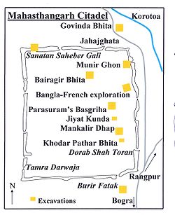
The citadel (see map alongside), the fortified heart of the ancient city, is rectangular in plan, measuring roughly 1.523 km long from north to south, and 1.371 km from east to west, with high and wide ramparts in all its wings. The Karatoya, once a mighty river but now a small stream, flows on its east.[2]
Till the 1920s, when excavations started, the inside of the citadel was higher than the surrounding areas by over 4 metres and was dotted with several straggling elevated pieces of land. The rampart looked like a jungle clad mud rampart with forced openings at several points. The rampart was 11–13 metres higher than the surrounding area. At its south-east corner stood a mazhar (holy tomb). A later day mosque (built in 1718-19) was also there.[7]
At present there are several mounds and structural vestiges inside the fortifications. Of these a few of note are: Jiat Kunda (well possessing life giving power), Mankalir Dhap (place consecrated to Mankali), Parasuramer Basgriha (palace of a king named Parasuram), Bairagir Bhita (palace of a female anchorite), Khodar Pathar Bhita (place of stone bestowed by God), and Munir Ghon (a bastion). There are some gateways at different points: Kata Duar (in the north), Dorab Shah Toran (in the east), Burir Fatak (in the south), and Tamra Dawaza (in the west)[2] At the north-eastern corner there is a flight of steps (a later addition) that goes by the name of Jahajghata. A little beyond Jahajghata and on the banks of the Karatoya is Govinda Bhita (a temple dedicated to Govinda). In front of it is the site museum, displaying some of the representative findings. Beside it is a rest house.
[edit]Suburb of the citadel
Besides the fortified area, there are around a hundred mounds spread over an area with a radius of 9 km. (See map alongside).
Excavated mounds[2]:
- Gobhindo Bhita, a temple close to the north-eastern corner of the citadel.
- Khulnar Dhap, a temple 1km north of the citadel.
- Mangalkot, a temple 400m south of Khulnar Dhap.
- Godaibari Dhap, a temple 1km south of Khulnar Dhap.
- Totaram Panditer Dhap, a monastery 4km north-west of the citadel.
- Noropotir Dhap (Vashu Bihara), a group of monasteries 1km north-west of Totaram Ponditer Dhap (said to be the place where Po-shi-po Bihara mentioned by Xuanzang (Hieun Tsang) was located).
- Gokul Medh (Lokhindorer Bashor Ghor), a temple 3km south of the citadel.
- Shkonder Dhap, a temple 2km south-east of Gokul Medh.
Major unexcavated mounds[2]:
- Shiladebir Ghat.
- Chunoru Dighi Dhap.
- Kaibilki Dhap.
- Juraintala.
- Poroshuramer Shobhabati.
- Balai Dhap.
- Prochir Dhibi.
- Kanchir Hari Dhibi.
- Lohonar Dhap.
- Khujar Dhap.
- Doshatina Dhap.
- Dhoniker Dhap.
- Mondirir Dorgah.
- Bishmordana Dhibi.
- Malinar Dhap.
- Malpukuria Dhap.
- Jogir Dhap.
- Podmobhatir Dhap.
- Kanai Dhap.
- Dulu Mojhir Bhita.
- Podda Debhir Bhita.
- Rastala Dhap.
- Shoshitola Dhap.
- Dhonbandhor Dhap.
- Chader Dhap.
- Shindinath Dhap.
- Shalibahon Rajar Kacharibari Dhipi.
- Kacher Angina.
- Mongolnather Dhap.
- ChhoutoTengra/ Babur Dhap/ Kethar Dhap.
- Boro Tengra/ Shonyashir Dhap.
.JPG)
[edit]Excavations
Systematic archaeological excavation of Mahasthangarh was first started in 1928-29 under the guidance of K.N.Dikshit of the Archaeological Survey of India. The areas around Jahajghata, Munir Ghon and Bairagir Bhita were explored. Excavation was resumed in 1934-36 at Bairagir Bhita and Govinda Bhita. Excavation was carried out in 1960s around the Mazhar, Parasuramer Prasad, Mankalir Dhap, Jiat Kunda and in a part of the northern rampart. In the next phase excavation was carried out sporadically in parts of the east and north ramparts but the final report is yet to be published. In the period 1992-98 excavation was conducted in the area lying between Bairagir Bhita and the gateway exposed in 1991 as a Bangla-Franco joint venture, which is now in its second phase with excavation around the mazhar in the western side of the citadel.[10]
[edit]Movable antiquities

The excavations have led to the recovery of a large number of items, a few of which are listed here.
Inscriptions: A 4.4 cm x 5.7 cm lime stone slab bearing six lines in Prakrit in Brahmi script, discovered accidentally by a day labourer in 1931 was an important find. The text appears to be a royal order of Magadh, possibly during the rule of Asoka. It dates the antiquity of Mahasthangarh to 3rd century BC. An Arabic inscriptional slab of 1300-1301 discovered in 1911-12 mentions the erection of a tomb in honour of Numar Khan, who was a Meer-e-Vahar (lieutenant of the naval fleet). A Persian inscriptional slab of 1718-19 records the construction of a mosque during the reign of the Mughal emperor Farrukhshiyar.[11]
Coins: Silver punch marked coins are datable to a period between the 4th century BC and the 1st-2nd century AD. Some uninscribed copper cast coins have been found. Two Gupta period coins have been reported from a nearby village named Vamanpara. A number of coins belonging to the sultans of 14th-15th century and British East India Company have been found.[11]
Ceramics: Mostly represented by a vast number of shards.[11]
Sculpture: A 5th century Buddha stone sculpture recovered from Vasu Vihara, a Lokesvara stone sculpture showing blending of Visnu and Avalokitsvara, salvaged from neighbouring Namuja village, a number sand stone door-frames, pillars and lintels (datable to 5th-12th century), numerous Buddha bronze sculpture datable to 10th-11th century, a terracotta Surya discovered at Mankalir Bhita, and numerous other pieces.[11]
Terracotta Plaques: A number of terracotta plaques have been discovered.
Many of these are on display in the site museum, which is open Sunday to Thursday summer:10 am to 6 pm, winter:9 am to 5 pm. Recess:1-2 pm, Friday recess is from 12.30 to 2.30, opens at 9 am in summer, other timings same. Summer timings 1 April to 30 September, winter timings 1 October to 30 March.[2] Books on Mahasthangarh and other archaeological sites in Bangladesh (in Bengali and English) are available at the ticket counter for the site museum.
[edit]Highlights of some excavated sites
[edit]Inside the citadel
Bairagir Bhita: Constructed/ reconstructed in four periods: 4th-5th century AD, 6th-7th century, 9th-10th century, and 11th century. Excavations have revealed impoverished base ruins resembling temples. Two sculptured sand stone pillars have been recovered.[12]
Khodarpathar Bhita: Some pieces of stone carved with transcendent Buddha along with devotees in anjali (kneeling with folded hands) recovered.[12]
Parasuramer Prasad: Contains remains of three occupation periods - 8th century AD findings include stone Visnupatta of Pala period, 15th- 16th century findings include some glazed shreds of Muslim origin, and the third period has revealed two coins of the British East India Company issued in 1835 and 1853.[12]
Mankalir Dhap: terracotta plaques, bronze Ganesha, bronze Garuda etc. were discovered. Base ruins of a 15-domed mosque (15th-16th century) was revealed.[12]
Bangla-Franco joint venture: Excavations have revealed 18 archaeological layers, ranging from 5th century BC to 12th century AD, till virgin soil at a depth of around 17 m.[12]
[edit]Outside the citadel
Govinda Bhita: Situated 185 m north-east of Jahajghata and opposite the site museum. Remains dated from 3rd century BC to 15th century AD. Base remains of two temples have been exposed.[12]
Totaram Panditer Dhap: Situated in the village Vihara, about 6 km north-west of the ciradel. Structural remains of a damaged monastery have been exposed.[12]
Narapatir Dhap: Situated in the village Basu Vihara, 1.5 km north-west of Totaram Panditer Dhap. Base remains of two monasteries and a temple have been exposed. Cunningham identified this place as the one visited by Xuanzang (Hiuen Tsang) in the 7th century AD.[12]
Gokul Medh: Also known as Behular Basar Ghar or Lakshindarer Medh, situated in the village Gokul, 3 km to the south of the citadel, off the Bogra-Rangpur road, connected by a narrow motorable road about 1 km. Excavations in 1934-36 revealed a terraced podium with 172 rectangular blind cells. It is dated 6th-7th century. Local mythology associates it with legendaryLakshmindara-Behula. The village Gokul also has several other mound Kansr Dhap has been excavated.[12]
Skandher Dhap: Situated in village Baghopara on the Bogra-Rangpur road, 3.5 km to the south of the citadel, a sandstone Kartika was found and structural vestiges of a damaged building were revealed. It is believed to be the remains of Skandha Mandira (temple consecrated to Kartika), mentioned in Karatoya mahatmya, as well as Kalhan’s Rajatarangin, written in 1149-50. There also are references to Skandhnagara as a suburb of Pundranagara. Baghopara village has three other mounds.[12]
Khulnar Dhap: Situated in village Chenghispur, 700 m west of the north-west corner of the citadel has revealed remains of a temple. The mound is named after Khullana, wife of Chand Sadagar.[12]
From the present findings it can be deduced that there was a city called Pundravardhana at Mahasthangarh with a vast suburb around it, on all sides except the east, where the once mighty Karatoya used to flow. It is evident that the suburbs of Pundravardhana extended at least to Baghopara on the south-west, Gokul on the south, Vamanpara on the west, and Sekendrabad on the north.[13] However, the plan of the city and much of its history are still to be revealed.[14]
Bhimer Jangal This well-known embankment starts from the north-east corner of Bogra town and proceeds northwards for about 30 miles to a marshy place called Damukdaher bit, under police station Govindaganj (Rangpur District) and it is said, goes oil to Ghoraghat. It is made of the red earth of the locality and retains at places even now a height of 20 feet above the level of the country. There is a break ill it of over three miles from Daulatpur (north west of Mahasthan-garh) to Hazaradighi (south-west, of it). About a mile south of Hazradighi. the stream Subil approaches the jangal and runs alongside it down to Bogra town.
Some people think that the Subil is a moat formed by digging the earth for the jangal but as there is no embankment on the northern reach of the Subil now called the Ato nala. which merges in the Kalidaha bil; north of Mahasthan-garh O'Donnell was probably right in saying that the Subil represents the western of the two branches into which the Karatoya divided above Mahasthan.
On the Bogra-Hazradighi section of thee jaligal, there are two cross embankments running down to the Karatoya, about 2 miles and 4 miles respectively north of Bogra town and there is a diagonal embankment connecting these cross bonds and then running along the Karatoya until it meets the main embankment near Bogra.
This jangal or embankment appears to have been of a military character, thrown up to protect the country on its east. The break roar Mahasthan may be due to the embankment having been washed away or to the existence of natural protection by the bit.
The Bhima to whom the embankment is ascribed may be the Kaivarta chief of the eleventh century who according to the Ramcharitam ruled over Varendra in succession to his father Rudraka and uncle Divyoka, who had ousted king Mahipala II of the Pala, dynasty. Bhima in his turn was defeated in battle and billed by Ramapala. Mahipala's son.
Jogir Bhaban South west of Bagtahali (beyond Chak Bariapara) and some 3 miles west of the khetlal road is a settlement of the Natha sect of Saiva sannyasis, known as Yogir-bhavan, forming the eastern section of Arora village. An account of this settlement is given by Beveridge, J.:1.S.T., 1878; p. 94. It occupies about so, bighas of land and forms the headquarters of the sect. of which there are branches at Yogigopha and Gorakh-kui, both in the Dinajpur District, the.former in its south-west part some 5 miles west of Paharpur, J.A.S.B.1875, p. 189, and the latter in its north-west part some 4 miles west of Nekmardan.
The shrines at Yogir-bhavan are situated in the south-west corner of an en¬closure or-math. One of them called Dharmma-dungi, bears a brick inscription, reading scrvva-siddha sana 1148 Sri Suphala ... (the year =1741 A.D.). 'In front of it is another shrine called `Gadighar,' where a fire is kept burn at all hours. Outside the enclose are four temples, dedicated respectively to Kalabhai¬rava, Sarvamangala Durga and Gorakshanatha. The Kalabhairava temple contains a diva linga and bears a brick inscription reading Sri Ramasiddha sana 1173 sala (=1766 A.D.) ample Sri Jayanatha Nara-Narayana. The Sarva¬mangala temple contains three images of Hara-Gauri, one of Mahishamardini, a fragment of an Ashta-matrika slab, a fragment of a three-faced female figure probably Ushnishavijava (Sadhanamala; II. pl.XIV) and a four-armed female figure playing on a vina (evidently Sarasvati, but worshipped here as Sarva¬ mangala). Over the entrance is a brick inscription reading 1089 Meher Natha sadaka sri Abhirama Mehetara (the year =1681 A.D.). In the Durga temple is a stone image of Chamunda, and in the Gorakshanatha one, a Siva lihga. There are three brick built samadhis near the latter temple.
Arora South-west of the Dadhisugar and standing on the Masandighi, in Arora village; is Salvan Rajar bari referred to under Baghahali. This Silvan may possibly be the same as king Salavahan, son of Sahila-deva of the Chamba inscription who won the title of Kari-ghata-varsha (= hunjara-ghata-varsha ?) (R.C. Majumdar, vange kambojadhikara,' vanga-rani,Chaitara, 1330.B.S.p. 251, ind.Ant,XVII.pp. 7–13). Beveridge refers to this mound in JA.S.B., 1878, p 95.
This name of Sahila seems, to occur again in Sahiladitya lakshmam in v. 10 of the Silimpllr inscription (Ep. Ind,XIII, p. 291). If this identification is correct, then the word kaunjanraghatacarshcna in the Bangarh stone inscription (Gauda-raja-mala, p. 35) is really the title or virudha of the Gudapati of the Kumboja family and not the date of the inscription.
Teghar North of Chandnia hat the road skirts the bil and comes to Teghar village Which juts out into the bil 'Near about here are several mounds; such as Naras¬patir dhap. Kacher Angina (or glazed courtyard, a term applied to many ruins in these parts) etc. The biggest of these mounds, Mangal-nather dhap, (Fig. 6) is situated close to the point, from which a road branches off to Bihar. It is said that terra-cotta plaques as well as stone images were found at this site, but were all consigned to the neighbouring dighi.
Rojakpur Proceeding westward along the road from Gokul to Haripur, we pass into the western arm of the latter village, already referred to. and meet the Bogra¬ Khetlal road near the Chandnia hat. West of Haripur and south of the Somrai bil is the village of Rojakpur, into which, as already stated, the elevated ground from Chandnia hat extends. On this ground are two mounds called respectively Chandbhita. (probably referring to the Manasa legend) and Dhanbhandar. A little further west is another mound called Singhinath Dhap.
Mathura East of Bumanpara and extending up to the garh on the east and the Kalidaha bill on the north, is the village of Mathura, in Which there are several tank and on a ridge overlooking the Gilatala moat, two mounds called Parasuramer Sabhabati and Yogir Dhap.
[edit]Threats to Mahasthangarh
In a 2010 report titled Saving Our Vanishing Heritage, Global Heritage Fund identified Mahasthangarh as one of 12 worldwide sites most "On the Verge" of irreparable loss and damage, citing insufficient management (poor water drainage in particular) and looting as primary causes.[15]
[edit]Anecdote
There is a local legend that Shah Sultan Balkhi Mahisawar arrived at Pundravardhana in the garb of a fakir (mystic holy pedlar of Islamic philosophy) riding a fish. (Mahisawar is Sanskrit-Persian word meaning a person who rides a fish). He came from Balkh in Afghanistan with a retinue. The period of his arrival is variably put at 5th century AD, 11th century AD and 17th century AD. At that time there was a king named Parasuram with his seat and palace in Mahasthangarh. Mahisawar requested Parasuram for a piece of land to spread his prayer mat on which he could pray. The request was granted but the prayer mat started expanding as soon as it was laid on the ground. When the prayer mat reached the area around the palace bewildered Parasuram declared war. In the beginning the battle seemed to be favouring Parasuram. A scavenger Harapala informed Mahisawar that it was difficult to defeat the royal troops because of the pool called Jiat Kunda. A dead soldier bathed in the waters of Jiat Kunda came back to life. On knowing this Mahisawar asked a kite to drop a piece of beef in Jiat Kunda. When this was done, the pool lost its powers. The royal troops were on the verge of defeat. The commander of the royal troops, Chilhan, with a large number of his followers, went over to Mahisawar. Thereafter Parasuram and many members of the royal family committed suicide.[6] There are many variations of this anecdote, some of which are sold in Bengali booklets in and around Mahasthangarh/Pundravardhana.
[edit]Some antiquity comparisons
Mahasthangarh dates back to at least 3rd century BC and is acknowledged as the earliest city-site so far discovered in Bangladesh. Somapura Mahavihara at Paharpur in Naogaon District was once the biggest Buddhist monastery south of the Himalayas. It dates from the 8th century AD. Mainamati ruins in Comilla District date back to 6th-13th centuries AD.[8] In neighbouring West Bengal, the ruins of Pandu Rajar Dhibi on the banks of the Ajay River in Bardhaman district date back to 2000 BC. However, this recent archaeological discovery has not yet been properly studied by outside experts and specialists in this field, and as such the historical value of many of the statements must be considered as uncertain.[16] The ruins at Chandraketugarh in 24 Parganas South and Rajbadidanga in Murshidabad district date back to the early years of the Christian era.[17]


.JPG)
.JPG)

.JPG)
.JPG)
.JPG)
.JPG)
.JPG)
.JPG)
.JPG)
.JPG)
.JPG)
No comments:
Post a Comment
Note: Only a member of this blog may post a comment.